🖰 AGENT'S WEBSITE - click on card 🖰
AGENTS: john @ olr.ca or Email button above, INCLUDE your website URL, your TAG LINE and attach your business card (GIF, JPG or PNG)
🖰 AGENT'S WEBSITE - click on card 🖰
AGENTS: john @ olr.ca or Email button above, INCLUDE your website URL, your TAG LINE and attach your business card (GIF, JPG or PNG)

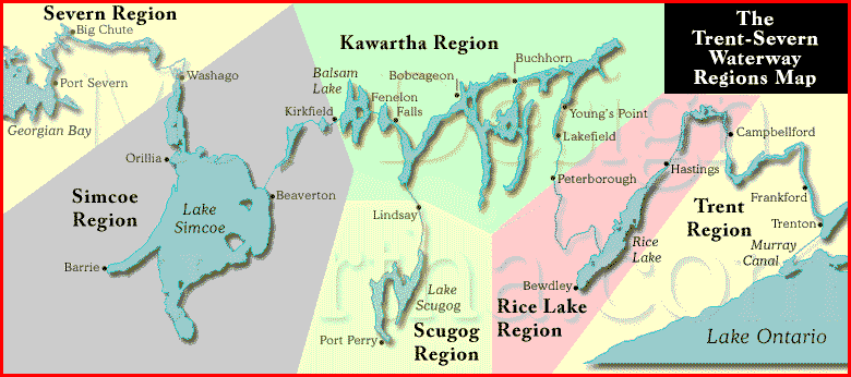
The Trent Severn Waterway, Trent Canal web site offers maps, lock locations, GPS coordinates, distance from lock to lock chart, hours of operation, history of The Trent Severn Waterway, links to Parks Canada who are responsible for The Waterway. Trent Severn Maps include a printable map you can take with you plus quick map links for 35 Towns with streets, grocery store and LCBO and beer store locations all sized to fit your phone or tablet. Trent Severn connects Trenton on Lake Ontario to Port Severn on Georgian Bay. A distance of 387 km (240 miles) and a rise of 180 meters (590 feet) above Lake Ontario and 80 meters (260 feet) above Georgian Bay at the Trent systems highest point, Balsam Lake. The lifting and dropping process incorporate 41 locks, a marine railway and two hydraulic lift locks including the worlds highest, 65 foot lift (20 meters), located at Peterborough Ontario. The system was started in 1833 and completed in 1920. We have added quick links to 10 translated languages.
May 19 to June 18, 2023
Monday to Thursday
10:00am - 3:30pm
Friday to Sunday; and Victoria Day (May 22)
9:00am to 6:30pm
Jun 19 to Sept 4, 2023
Monday to Thursday
9:00am – 5:30pm
Friday to Sunday; and Canada Day (July 1), Civic Holiday (Aug. 7),
Labour Day (Sept. 4)
9:00am to 6:30pm
Sept 5 to Oct 9, 2023
Monday to Friday
10:00am to 3:30pm
Saturday - Sunday; and Thanksgiving (Oct. 9)
9:00am to 4:30pm
LAST LOCKAGE - IMPORTANT
All vessels must arrive at the designated blue zone at least 30 minutes before closing time.
At swing bridges, the last bridge swing will be 20 minutes prior to closing time.
NOTE: Station opening and last lockage times are not guaranteed
Links to Parks Canada:
Tel: 705-750-4900 or
Tel: 1-888-773-8888 or
Email: information@pc.gc.ca
1, Trenton, 44.122102,-77.5945094, Trent, 0 - 0 , 2021
2, Sidney, 44.1299248,-77.593872, Trent, 3.9 - 2.4 , 2021
3, Glen Miller, 44.1550178,-77.587308, Trent, 6.2 - 3.9 , 2021
4, Batawa, 44.1681178,-77.5884711, Trent, 8.3 - 5.2 , 2021
5, Trent, 44.1852363,-77.593925, Trent, 10.3 - 6.4 , 2021
6, Frankford, 44.1978221,-77.5935244, Trent, 11.7 - 7.3 , 2021
7, Glen Ross, 44.2661165,-77.5984492, Trent, 22.2 - 13.8 , 2021
8, Percy Reach, 44.2362137,-77.7864701, Trent, 40.7 - 25.3 , 2021
9, Meyers, 44.247155,-77.8023595, Trent, 42.5 - 26.4 , 2021
10, Hauges Reach, 44.2674334,-77.7958095, Trent, 45.0 - 28.0 , 2021
11/12, Ranney Falls, 44.2915204,-77.8155936, Trent, 47.8 - 29.7 , 2021
13, Campbellford, 44.3196533,-77.7886936, Trent , 51.8 - 32.2 , 2021
14, Crowe Bay, 44.2331236,-77.7523884, Rice Lake, 54.2 - 33.7 , 2021
15, Healy Falls, 44.370739,-77.7805857, Rice Lake, 58.2 - 36.2 , 2021
16/17, Healy Falls, 44.3728352,-77.7817333, Rice Lake, 58.8 - 36.5 , 2021
18, Hastings, 44.3083532,-77.9588177, Rice Lake, 82.3 - 51.1 , 2022
19, Scott's Mill, 44.2886853,-78.3107699, Rice Lake , 142.8 - 88.7 , 2022
20, Ashburnham, 44.2995225,-78.3066252, Kawartha, 144.5 - 89.5 , 2023
21, Peterborough, 44.3076708,-78.3027591, Kawartha, 145.0 - 90.1 , 2023
22, Nassau Mills, 44.3653615,-78.2926905, Kawartha, 151.7 - 94.3 , 2023
23, Otonabee, 44.3724787,-78.2896806, Kawartha, 152.6 - 94.8 , 2023
24, Douro, 44.3886236,-78.2716549, Kawartha, 155.1 - 96.4 , 2023
25, Sawer Creek, 44.4006726,-78.2650433, Kawartha, 156.6 - 97.3 , 2023
26, Lakefield, 44.4191165,-78.271359, Kawartha, 158.9 - 98.7 , 2023
27, Young's Point, 44.4881567,-78.2349991, Kawartha, 168.1 - 104.5 , 2023
28, Burleigh Falls, 44.5599164,-78.2100727, Kawartha, 181.8 - 113.0 , 2023
30, Lovesick, 44.5529251,-78.2418823, Kawartha, 182.7 - 114.8 , 2023
31, Buckhorn, 44.555173,-78.3493427, Kawartha, 194.2 - 120.7 , 2023
32, Bobcageon, 44.5375815,-78.5479718, Kawartha , 222.4 - 138.2 , 2025
33, Lindsay, 44.3573749,-78.7374048, Sucog , 251.6 - 156.3 , 2026
34, Fenelon Falls, 44.5360586,-78.7395755, Kawartha, 247.2 - 153.6 , 2025
35, Rosedale, 44.5717862,-78.7802627, Kawartha, 252.9 - 157.2 , 2025
36, Kirkfield, 44.5896663,-78.9921701, Kawartha , 272.6 - 169.4 , 2025
37, Bolsover, 44.5099486,-79.1085168, Simcoe, 284.9 - 177.0 , 2025
38, Talbot, 44.5099486,-79.1085168, Simcoe, 286.5 - 178.1 , 2025
39, Portage, 44.498728,-79.1334042, Simcoe, 289.1 - 179.6 , 2025
40, Thorah, 44.4939798,-79.1403957, Simcoe, 289.8 - 180.1 , 2025
41, Gamebridge, 44.4866986,-79.151467, Simcoe, 290.9 - 180.7 , 2025
42, Couchiching, 44.7698083,-79.3502941, Simcoe , 337.8 - 209.9 , 2028
43, Swift Rapids, 44.5718121,-78.7825531, Severn, 361.2 - 224.5 , 2029
44, Big Chute, 44.5718121,-78.7825531, Severn, 374.1 - 232.5 , 2029
45, Port Severn, 44.5718121,-78.7825531, Severn, 387.1 - 240.6 , 2029
The start to finish time line spans eighty-seven years with the systems construction
starting in 1833 at Bobcaygeon and finishing in 1920 at Port Severn, three
hundred and eighty-seven kilometers from Lake Ontario. The Navigation channel
runs a depth of six feet from start to finish.
The locks vary in raising the
water level some exceptions are; flight locks, the Big Chute Marine Railway
with a lift of eighteen meters (58 feet), the Kirkfield Lift Lock with an average
lift of fifteen meters (49 feet) )and the Peterborough Lift Lock (finished
in 1904) with a lift of twenty meters (65 feet).
Peaking at Balsam Lake at 180 meters (600 feet) above Lake Ontario and 80 meters
(250 feet) above Lake Huron's, Georgian Bay.
Standard lock dimensions are one hundred and twenty feet long by thirty-two feet wide. The two exceptions are the lock 44, the Big Chute Marine Railway at one hundred feet long by twenty-four feet wide and lock 45 at Port Severn is only eight-four feet long and twenty-three feet wide setting the limit if you wish to traverse The Trent Severn Waterway from one end to the other.
Two major upgrades were at Big Chute in 1960 and combining two locks at Burleigh Falls in 1968 eliminating lock 29.
Navigation here is easy, all the key data is on one page. A click to the printable map or business directory or towns you pass by with quick links to their street map, grocery shopping, LCBO and region.
Enjoy relaxing, activities or the sights of Central Ontario including the Peterborough Lift Lock or the Big Chute Marine Railway.
Balsam Lake is the highest point in the system. Kirkfield is 14.9 m below Balsam and Rosedale 1.2 m below.
The Kirkfield Lift Lock Chambers rise to one foot below Balsam Lake, the system works when Balsam fills this area in the chamber increasing the weight, allowing it to descend so the opposite chamber to can rise. The chamber coming down must always have more water (weight) for the design to function.
There is no lock 29 as two locks were replaced by one at Burleigh Falls.
Purdey's Mills aka Lindsay aka City of Kawartha Lakes, is a side branch of
The Trent-Severn Waterway accessing Lake Scugog.

continued ...
... Brief History continued
Standard lock dimensions are one hundred and twenty feet long by thirty-two feet wide. The two exceptions are the lock 44, the Big Chute Marine Railway at one hundred feet long by twenty-four feet wide and lock 45 at Port Severn is only eight-four feet long and twenty-three feet wide setting the limit if you wish to traverse The Trent Severn Waterway from one end to the other.
Two major upgrades were at Big Chute in 1960 and combining two locks at Burleigh Falls in 1968 eliminating lock 29.
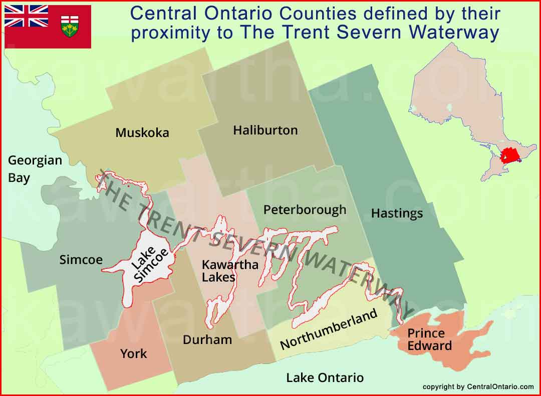
The Trent Severn Waterway is Central Ontario's 387 kilometers of waterway utilizing 41 locks, a marine railway and 2 hydraulic lift locks. The highest point, Balsam Lake is 180 meters (590 feet) above Lake Ontario and 80 meters (260 feet) above Georgian Bay.
Navigation here is easy, all the key data is on one page. A click to the printable map or business directory or towns you pass by with quick links to their street map, grocery shopping, LCBO and region.
Enjoy relaxing, activities or the sights of Central Ontario including the Peterborough Lift Lock or the Big Chute Marine Railway.
Balsam Lake is the highest point in the system, not Rosedale or Kirkfield. Kirkfield is 14.9 m below Balsam and Rosedale 1.2 m below.
The Kirkfield Lift Lock Chambers rise to one foot below Balsam Lake, the system works when Balsam fills this area in the chamber increasing the weight, allowing it to descend so the opposite chamber to can rise. The chamber coming down must always have more water (weight) for the design to function.
There is no lock 29 as two locks were replaced by one at Burleigh Falls.
Purdey's Mills aka Lindsay aka City of Kawartha Lakes, is a side branch of The Trent-Severn Waterway accessing Lake Scugog.
The Trent-Severn Waterway over the years has been called simply trent severn or severn travel or trent severn canal or trent severn water or trent waterway or severn canal or trent canal and all names aptly describe The Trent Severn Waterway. Here at our site, TheTrentSevernWaterway.com, we source the single details that you will need to use this resource running through Central Ontario, Canada.
We believe that if a group or a region is successful, all within are successful. For Central Ontario the catalyst that binds the region are tourists wanting to visit, people that leave other areas to settle here, real estate that meets and exceeds expectations along with great unique tourist attractions.
View the map and you can see that The Trent Severn Waterway (TTSW) is the backbone of the region. It weaves and touches towns and villages that prosper and are in demand by people wishing to settle. Many other attractions are available as well. Farmer's markets, parks, First Nations, Festivals and the list can go on.
What is the reason you ask for the agents ads at the top of the pages. Simply, you want a local agent to address your Real Estate needs. They understand the value of properties in their respective areas plus all the pros and cons. For example does an agent from Toronto understand the unique markets in the outlying counties? Probably not as well as local.
Just like the TTSW (ttsw.ca) binds the regions we want Central Ontario and it's group of websites to bind the real estate market into a unique experience for seller and buyer alike. When it comes to web sites we will use the following to assist centralontario.com. TheTrentSevernWaterway.com, Kawartha.com, OntarioCottages.com, CottageCountryOntario.com and CanadianExposure.com to give it a broader view.

National Post - Canada
Global News - Canada
CTV News - Canada
Toronto Star - Canada
The Rebel - Canada
The Correspondent - Canada/World
Vancouver Sun - Canada
Montreal Gazette - Canada
Conservative Party of Canada
Liberal Party of Canada
NDP Party of Canada
Green Party of Canada